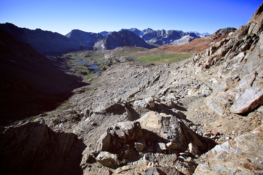
Looking back down the way we had come from our camp at 12,250 ft. What a long day.
-llg
Looking back down the way we had come from our camp at 12,250 ft. What a long day.
-llg

The weather was a bit funky as we camped in the shadow of Forester Pass that night. A few rain drops threatened to ruin our dry record on the trail, no real rain on us the entire hike! Luckily, as the sun set, the clouds broke. Then it got COLD.
-llg

This mountain had a serious resemblance to a pyramid. Very symmetrical and triangular. Walked like an Egyptian all the way around it.
-llg

Despite this being a long, hard day, I was astute enough to keep shooting.
-llg

Another view of the Painted Lady as we scaled Glen Pass.
-llg

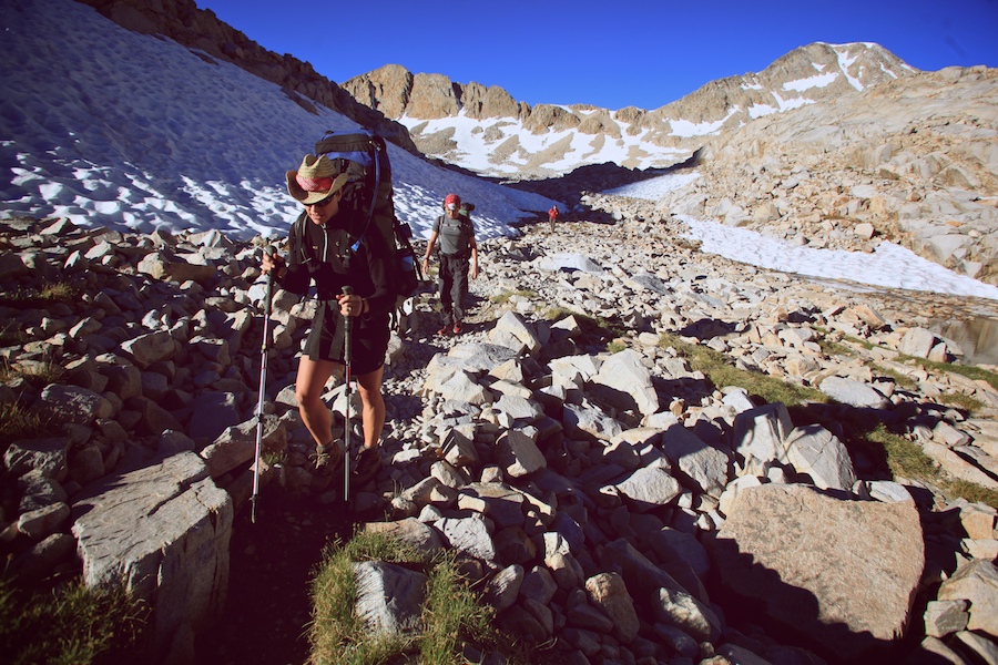
Friday, August 6th, Day 19. Somewhat brutal day today. Some days your heart just isn't into it, or should I say, the heart is into it but the head is not. Thought that the 2 or so miles to Glen Pass (11978 ft) this morning would be easy, but instead they were brutal. Long, hard, 1400 ft climb from Rae Lakes. Kept an eye out for the reputed big horn sheep that have been spotted here, but only saw some large male deer first thing out of camp.

Headed down to Vidette for a break and food assessment. Ran out of oatmeal yesterday, and I think its absence this morning hurt us. Have enough in the bear canisters to roll out of Whitney with zero calories. Climb out of Vidette (9515 ft) was loooooooong, and it seemed to really drag on forever. Sometimes it just seems like work, and hard work good, hard work fine, but first take care of head, as the man says. Day seemed to move on at a snail's pace. Camping at the Lake at 12,250 ft, hopefully will shoot over this pass without too much trouble in the AM.


Three of the young kids we met the 2nd day out are here after skipping a section and losing one hiker to a knee issue, and the Tres Penitos just showed up. Good to see part of 'our crew,' but they say that the rest (Cookie, Sunrise and Laughing Cloud) are shooting for Guitar Lake tomorrow, with a possible sunrise on Whitney Sunday morning! The idea immediately turned me off, but after hanging out with the boys for a bit, Bri and I are now tossing around the idea. We'll have to see how tomorrow treats us, as this pass today, though we've done most of it, really knocked the shit out of me, and had us a little worried about sleeping at this elevation. Either way, once this pass is behind us, Whitney is the next and last big climb, so that's good at least.


-llg

The beautiful peak that overlooked our camp on Rae Lakes, the last peak around to catch the sunset. Wouldn't have minded scaling it...maybe some other day. Click the pic to zoom on in.
-llg

What a wonderful set of lakes this was, split by a tiny peninsula of trail, close enough to bear the same name. The water was a little chilly, but just about perfect, compared to some of the cold water we had experienced. Click to view larger.
-llg

Another early rise after a long night of sleep. Heard a pack of coyotes as we were going to bed, close. Spooky sounding. Bri had a dream that they came up to the tent and stuck their noses under the rain fly, and one of the noses was black and familiar, and turned out to be [our dog] Rita. Hard to get up in the morning, was cold outside of the bag. Oatmeal, coffee, morning constitutional. Used last square of toilet paper...and this being pine country, there's not too many leaves around here...gonna have to be journal pages for the next five mornings I guess.
Set off on a steep 1-2 miles to Pinchot Pass (12130 ft), another gorgeous view both north and south. Had only one oatmeal packet this morning, the last two in the bear box, so got immediately hungry as we climbed. Forced myself to not eat the bar in my pocket, thinking of John Muir himself, who only carried some tea and a bit of hard tack or bread on his long excursions. If he could hike hungry, so shall I...then again, he didn't carry 50 lbs on his back...
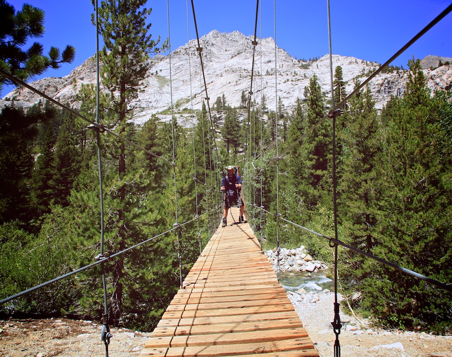
Over the course of the day, the hunger strategy seemed to work: hiked about 8 miles down to low elevation point for the day in one fell swoop, with one Snickers along the way. At Woods Creek crossing, with a large suspension bridge over the water, had last chunk of summer sausage and a tuna tortilla. Not stuffed, better for hiking after the break.
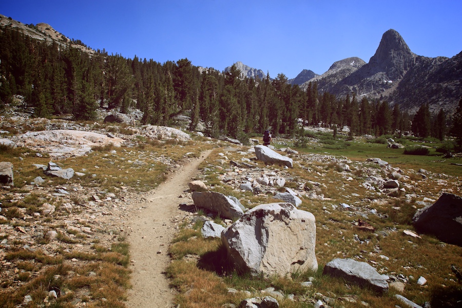
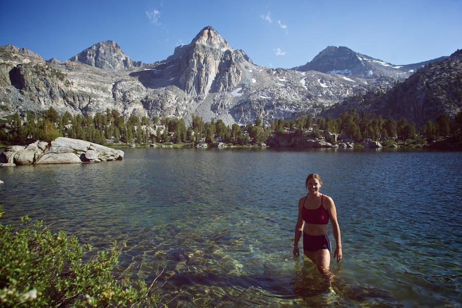
Was worried about last 7 miles up into the valley toward Rae Lakes and Glen Pass, over 2000 ft up just to our camp, in the heat of the day, but we managed it nicely and had plenty of time for one of the most beautiful swims so far, under the Painted Lady and surrounding peaks. Nice little spot, almost all alone, but could hear some yahoos across the lake having a good time. It's 8:30, and we are going to BED.
-llg

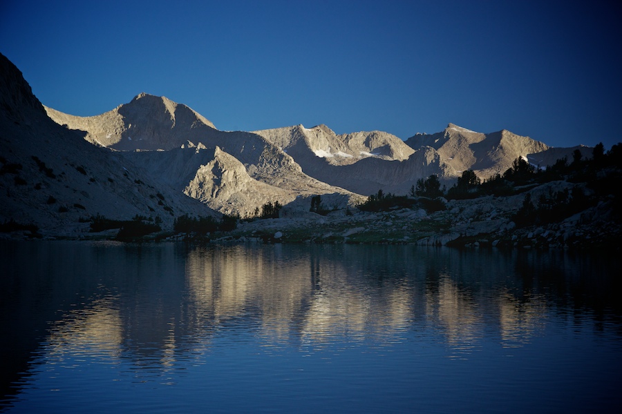
Early morning view from our camp on Lake Marjorie. Click to zoom in.
-llg

As we topped the Golden Staircase, this is what we saw. Reward!
-llg

As I mentioned in the previous post, you could often trace the trail ahead of you from the top of a pass. Mather was the most amazing one for this, as the switchbacks were über-steep and curved hard to the left before dropping quickly to an alpine valley that headed off to the right, so the trail got distant fast, but easy to follow across barren terrain. I tried my hand at a VERTICAL panoramic here, shooting down at the trail as some hikers crossed the valley. The posted photograph above is a small crop of the much larger photo, which is below at my maximum width for the content on this blog. If you click it, it will bring up a 7.5 mb file that is still a greatly reduced size to the original file, but at this level, you can already see how my lens kinda flat out SUCKED at the edges of the frames, which manifests in the final composite as blurry sections surrounded by the sharper portions of the frames they have been married with. I suggest you right-click and 'Save File As' so you can pixel-peep it in the image app of your choice...

This is the view opposite the previous post's. That was the amazing thing about going over the passes: they are the lowest high point that we would go over, the point at which the water either flows down one side and into one drainage, or the other, and into a wholly different drainage. The peaks around us would tower for days leading up to the final push over a pass, a long meandering journey thru lush valleys and meadows, then up some steep geological 'wall' into ANOTHER valley or meadow, seemingly like another world, and hard to fathom that this sat ABOVE the last valley that we had been in, like those cheesy sci-fi movies where people go into the center of the earth to find not caverns and darkness, but some sort of other world with a sun and life...
At the passes, this dichotomy of landscapes was the most visible, as you could stand and face the direction you had come, and see your approach as far as you could, maybe 3 miles, maybe 7, depending on the lay of land and what peaks you had come around; and turning, be faced with a whole new landscape, not necessarily vastly different from the one you just came out of, but always different in such a way that it felt NEW, and laid before you like that, sweeping out from the keyhole you stood upon, inviting you to trace the forward path as well as you could, switchbacks first, down the steep face, then across the valley below and down, down, to some river that carved out a low notch for later than day, or the next. From Mather, we could officially see our next pass, 10 miles away. We would cross it the next morning. There's nothing like that feeling, to see 10 miles into the future, to a place that you would walk to over the course of hours.
-llg

Another zoomable panoramic, with a little bit of me in there.
-llg

Editor's Note: The following is pulled from the journal that I kept while hiking the John Muir Trail this past month. I'll post each entry for the next few weeks. If you are just tuning in, you can go to the first day of the journal here.
Wednesday, August 4th, Day 17. Long day. Got started hiking at 5:50am, after oatmeal, instant coffee for me, packing up, and saying goodbye to the Russians, Evgeny and Ilena, who we probably won't see on trail again, after we shoot ahead the next few days.
Did a mile+ to get to the base of the Golden Staircase, a steep 1500ft climb up switchbacks thru giant talus. I think our guidebook said it was the last portion of the trail to be completed, and it certainly was an engineering feat, on a very well-built and maintained trail. Scooted up it without too much trouble, save the initial wave of mosquitoes that added insult to injury. Deeted up as I shed layers, first beanie, then fleece, then thermal top and pant legs.

Kept looking back to the valley we had come up, watching as the sun first hit the peaks across the way, then crept slowly down into the valley itself and across it towards us. Our climb was in the eastern direction, the mountain-side faced west, so we hid in it's own shadow as we climbed, always checking the sun's progress thru the valley, always staying ahead of it, until finally we topped out of Staircase and into the sun, full on, in the Palisade Lakes valley area. Our timing had been perfect, and we felt good (if ravenous, even eating snickers and clif bars on the way up), and though the grade lessened as we traversed past the Palisade Lakes, the true apex of our climb, Mather Pass, was still 3 miles up.
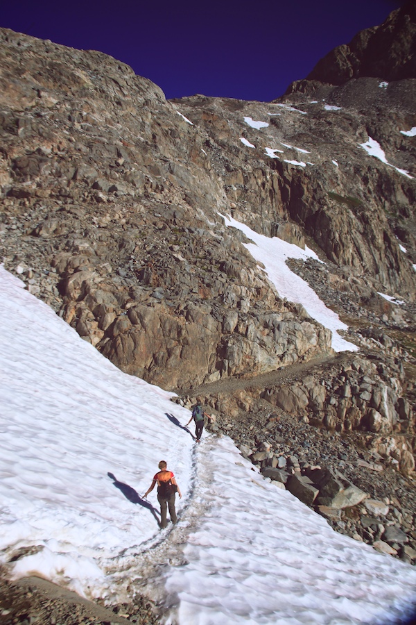
Stopped for water and a shit, then pressed on past smaller lakes and giant granite walls and peaks, thru talus and boulders and wild flowers aplenty. I'd say it was a typical alpine pass landscape, but each is so different that nothing is all that typical! Soon the grade steepened again and as usual, Bri pulled ahead, further and further, as I slowed down, both to take pictures and because I'm just generally slow (13 lbs of camera gear over here). Switchbacks and steepness, snow banks and massive rock steps (placed there by the Titans, apparently), and to top it all off, I was feeling a bit affected by the altitude on this particular climb, both light-headed and top-heavy at the same time.
Eventually, at around 10 past 11, we topped it out on Mather Pass (12,100 ft), the giant alpine valley behind us, and another landscape sweeping out below and before us. Had some GORP, then a crew of really annoying weekend warriors showed up. One guy had so much zinc oxide on his face that he looked like a porcelain albino circus clown. All were wearing one of the two styles of hats we had begun to see on all weekenders; either they were in the French Foreign Legion or the Dumbass Hat Brigade (the DHB). Sometimes we get easily annoyed with certain types of people, mainly the overly-informed, loose-tongue variety, so we split the scene. Steep switchbacks down the side of the pass brought us to a gently rolling hill-valley, and we cruised 6.4 miles down into the deeper valley without a break, taking a long rest with swim and dinner at the south fork of the King River. That was the low elevation of the day, so we started back up a dry, steep climb for a mile, then lesser grades thru lakes and gorgeous rocky meadows and highlands. At 5:50, 12 hours after we began hiking that day, we found camp on the shore of Lake Marjorie (11132 ft), where we jumped in naked, and got out quick. Coldest, bluest water I got into, so far today ;)
-llg
The night before we started over the intimidating Mather Pass, we slept in Deer Meadow, a small patch of living trees amidst a large burn and avalanche area. Nice little place to camp, now that there weren't active forest fires and avalanches falling on us.
-llg

A 180º panoramic, standing in the middle of the trail. Click to view larger.
-llg

One great thing about hiking in the morning is the calmness...which means the wind doesn't disturb the surface of a lake.
-llg
Editor's Note: The following is pulled from the journal that I kept while hiking the John Muir Trail this past month. I'll post each entry for the next few weeks. If you are just tuning in, you can go to the first day of the journal here.
Tuesday, Aug. 3rd, Day 16. Tried multiple nightlapses and stills last night. Too many things to work with: brilliant stars, a bright Milky Way, lakes, reflections, mountains, our tents! Did some stills then set up a so-so lapse of our tents. When I got up 2 hours later, I tried a few more still shots, then saw and even better lapse of our tents with the Milky Way above and the moonlight creeping in, so started that one. Must have gotten too cold, there's a lot of noisy, corrupted frames, and the battery died sometime before I got up to stop it. Think I'll chill on the night lapses for now.
Woke early to tackle the 7+ miles to LeConte Canyon and Bishop Pass trail junction where Brad and Julie were headed. Took a piss and shit in a nice little corner overlooking the unnamed lake we camped on, now part of me will always be there:) Steep downhill over freshly frozen snow pack patches tool some time, but as usual, the scenery was unreal, and the camera was constantly out. Much harder trail on this side of Muir Pass, I did not envy the northbound hikers we passed on the way down!!
Eventually the grade lessened, and we moved faster thru forests within the canyon, steep granite on either side. Bri's toe was beginning to hurt bad when we made it to the junction, said our goodbyes to B and J, and had a nice soak in the river there. Knocked out the next 3.4 downhill fast, then turned up from our lowest elevation until we reach the end of our journey (8070 ft), toward Mather Pass. Only went about 2 miles when we found the Russians, looking tired. They had been searching for a camp since the uphill began, but the forest was brutalized by avalanches, so nothing was campable. We pressed on a bit further with them to find a good spot in some intact forest, had a dip in Palisade Creek, cold as usual, dinner, chores, some Russian lessons, now bed. Tomorrow, a BIG 3000+ foot climb to Mather Pass, not looking forward to the Golden Staircase in the morning...
-llg

Another zoomable panoramic, this one photographed the next morning, on our unnamed lake camp. Muir Pass in to the southwest, tucked in between the near hill and the distant mountain on the left. Can you find the human element?
-llg